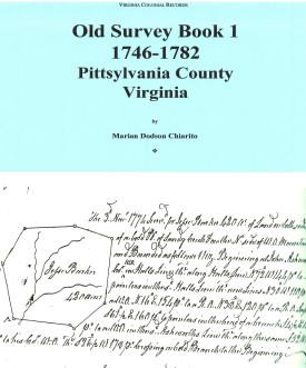
 OLD SURVEY BOOK 1, 1746-1782, PITTSYLVANIA COUNTY, VIRGINIA
transcribed by Marian Dodson Chiarito. 1988. 400 pages, 8" x 11.
OLD SURVEY BOOK 1, 1746-1782, PITTSYLVANIA COUNTY, VIRGINIA
transcribed by Marian Dodson Chiarito. 1988. 400 pages, 8" x 11.
PLEASE NOTE: This book contains surveys of land in
Pittsylvania County as it existed in 1767 when it was created from Halifax County. Until 1776, when Henry
County was formed, the counties of Henry, Franklin, and Patrick are also included.
It consists primarily of a
photocopy of the original surveys found in Old Survey Book 1. The map included with the book gives names
of most of the early watercourses, and makes possible the location of land surveys, adjoining landowners, etc.
A complete index of all names, watercourses, roads, etc. is provided.
To view a digital copy of the index to this book, visit Index-Pts1
(Close the pdf file with the left arrow to return to Iberian's catalog)
[Pts1] $37.00
The above title is also available as a digital e-book in PDF format:
[EPts1] $25.00
[EPts1] $25.00


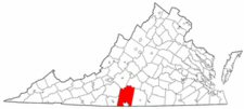 Pittsylvania County was established in 1767 from the western lands of Halifax County. The new county, the largest in Virginia at the present time, was named for William Pitt, first earl of Chatham, a famous British statesman who championed the Americans' claims prior to the Revolutionary War. In 1776 Henry County was formed from Pittsylvania. The county has remained stable since then.
 PITTSYLVANIA COUNTY, VA 1810 SUBSTITUTE CENSUS [Abstracts from the 1810 Personal Property Tax List]
by John Vogt, 2011, 8 1/2"x11" format, vi, 18 pages, map.
PITTSYLVANIA COUNTY, VA 1810 SUBSTITUTE CENSUS [Abstracts from the 1810 Personal Property Tax List]
by John Vogt, 2011, 8 1/2"x11" format, vi, 18 pages, map.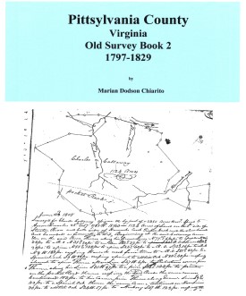 OLD SURVEY BOOK 2, 1797-1829, PITTSYLVANIA COUNTY, VIRGINIA
transcribed by Marian Dodson Chiarito. 1988. 102 pages, 8" x 11. This book contains surveys of land within the
present bounds of Pittsylvania County. Although this is a sequel to Old Survey Book 1, which contained
surveys made up to 1782, the first survey included in Book 2 was made in 1797. Therefore, survey records for
about fifteen years are not accounted for. In Entry Record Book 2, 1770-1796 (See HALIFAX COUNTY),
there are marginal notations that indicate some surveys were made during this fifteen-year interval. Old survey
Book 2 follows the same format as its predecessor, containing photocopies of the original surveys. The map
included is the same as that included in Book 1. A complete index of all names, watercourses, roads, etc. is
provided.
OLD SURVEY BOOK 2, 1797-1829, PITTSYLVANIA COUNTY, VIRGINIA
transcribed by Marian Dodson Chiarito. 1988. 102 pages, 8" x 11. This book contains surveys of land within the
present bounds of Pittsylvania County. Although this is a sequel to Old Survey Book 1, which contained
surveys made up to 1782, the first survey included in Book 2 was made in 1797. Therefore, survey records for
about fifteen years are not accounted for. In Entry Record Book 2, 1770-1796 (See HALIFAX COUNTY),
there are marginal notations that indicate some surveys were made during this fifteen-year interval. Old survey
Book 2 follows the same format as its predecessor, containing photocopies of the original surveys. The map
included is the same as that included in Book 1. A complete index of all names, watercourses, roads, etc. is
provided. Pittsylvania Co. 1815 Directory of Landowners
by Roger G. Ward. 2005. 49 pages, map, 5 1/2X8 1/2.
Pittsylvania Co. 1815 Directory of Landowners
by Roger G. Ward. 2005. 49 pages, map, 5 1/2X8 1/2. Pittsylvania Co. Revolutionary Public Claims
transcribed by Janice L. Abercrombie and Richard Slatten.. 2005. 43 pages, 5 1/2X8 1/2.
Pittsylvania Co. Revolutionary Public Claims
transcribed by Janice L. Abercrombie and Richard Slatten.. 2005. 43 pages, 5 1/2X8 1/2.