       
Home
Reference
Census Records Military
Other States New Titles E-BOOKS FREE SHIPPING
Iberian Publishing Company's On-Line Catalog:
1815 Virginia Landowners Booklets
 In 1782 the General Assembly of Virginia enacted new tax laws which
created within each county an enumeration of land and certain personal property. These
early land tax laws required a tax commissioner in each district of a county to record a
list of the names of persons owning land or town lots, the quantity of land owned and its
value, and the amount of tax owed. By 1813, a brief geographic description (usually
citing an adjacent stream, road, or other landmark) was required; in 1814, the distance
and direction from the courthouse for each parcel was also added to the tax rolls.
In 1782 the General Assembly of Virginia enacted new tax laws which
created within each county an enumeration of land and certain personal property. These
early land tax laws required a tax commissioner in each district of a county to record a
list of the names of persons owning land or town lots, the quantity of land owned and its
value, and the amount of tax owed. By 1813, a brief geographic description (usually
citing an adjacent stream, road, or other landmark) was required; in 1814, the distance
and direction from the courthouse for each parcel was also added to the tax rolls.
The present work is an alphabetical listing of all 1815 landowners found in
each county, as well as the accompanying description of the location of the said property.
We have not included the number of acres, taxes assessed, or any transactions between
landowners which may have been noted on the tax rolls; also, in many cases the
geographic location was provided as "adjacent to John Smith", etc. and, while useful many
times to a genealogist, was considered to be beyond the objectives of this project. The
reader is encouraged to consider the information here-in as an "outline" of early
landowners in Virginia rather than a "text" due to the year-to-year variation in
information provided to the clerk (or recorded by the clerk), omissions, lack of
"identifiers" to determine if "same name" was also "same person" within a district or
across districts, marginal quality/clarity (in a few cases) of the microfilm copy, and, not
least, errors on the part of either the original clerks or the current author while
transcribing.
Some of the approaches to utilizing the 1815 landowner information include:-
observe distinct clusters of the same surname within a county in order to clarify
the common surnames such as "Smith", "Anderson", etc;
- identify non-resident landowners and their county (or state) of residence (these
people often being former residents of the current county);
- determine neighbors with different surnames (often being relatives);
- use the 1815 information as a "bridge" from the 18th and 19th century deed/will
books to the 17th and 18th century land grants/patents in the county;
- evaluate the 1810 to 1840 census information which generally grouped
neighbors;
- substitute this information for missing deed/will books in the "burned" counties;
and, clarify/enhance vague deed/will information in the counties with more complete
records.
FORMAT OF PRESENTATION: Each entry is listed as: Surname,
name,
personal identifiers (if any); location/place-name of land; miles/direction from the 1815
courthouse. If multiple owners are listed for a property, the listing is duplicated under
each of the owner's surnames (i.e "Smith and Brown" is also listed as "Brown, --see
Smith"); when multiple owners share a common surname, the property is only listed
once. When a landowner had land at more than one location/place-name, the
miles/direction listing for each parcel is in the same sequence as the location listing (i.e.
James RV, Slate CK; 12N, 5SW.). In the few cases where a landowner had "many"
parcels, the miles/direction notation is attached to the location listing (i.e. Sandy RV-
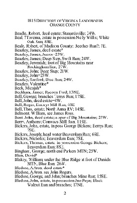
5NE, Willow CK-7S, etc.)(Sample page at right from Orange Co., VA 1815 Directory of Landowners)
The following is a list of county booklets for the
1815 Directory of Virginia Landowners
- Accomack Co. 1815 Directory of Landowners (52 pp.)
[Vd01] $9.00 (printed version)
The above title is also available as a digital e-book in PDF format:
[EVd01] $6.00 (electronic version)
- Albemarle Co. 1815 Directory of Landowners (52 pp.)
[Vd02] $9.00 (printed version)
The above title is also available as a digital e-book in PDF format:
[EVd02] $6.00 (electronic version)
- Alexandria Co. 1815 Directory of Landowners (13 pp.)
[Vd03] $5.00 (printed version)
The above title is also available as a digital e-book in PDF format:
[EVd03] $3.00 (electronic version)
- Amelia Co. 1815 Directory of Landowners (26 pp.)
[Vd04] $6.00 (printed version)
The above title is also available as a digital e-book in PDF format:
[EVd04] $4.00 (electronic version)
- Amherst Co. 1815 Directory of Landowners (30 pp.)
[Vd05] $7.00 (printed version)
The above title is also available as a digital e-book in PDF format:
[EVd05] $4.50 (electronic version)
- Augusta Co. 1815 Directory of Landowners (50 pp.)
[Vd06] $9.00 (printed version)
The above title is also available as a digital e-book in PDF format:
[EVd06] $6.00 (electronic version)
- Bath Co. 1815 Directory of Landowners (35 pp.)
[Vd07] $8.00 (printed version)
The above title is also available as a digital e-book in PDF format:
[EVd07] $5.50 (electronic version)
- Bedford Co. 1815 Directory of Landowners (49 pp.)
[Vd08] $9.00 (printed version)
The above title is also available as a digital e-book in PDF format:
[EVd08] $6.00 (electronic version)
- Berkeley Co. 1815 Directory of Landowners (51 pp.)
[Vd09] $9.00 (printed version)
The above title is also available as a digital e-book in PDF format:
[EVd09] $6.00 (electronic version)
- Botetourt Co. 1815 Directory of Landowners (51 pp.)
[Vd10] $9.00 (printed version)
The above title is also available as a digital e-book in PDF format:
[EVd10] $6.00 (electronic version)
- Brooke Co. 1815 Directory of Landowners (26 pp.)
[Vd11] $6.00 (printed version)
The above title is also available as a digital e-book in PDF format:
[EVd11] $4.00 (electronic version)
- Brunswick Co. 1815 Directory of Landowners (40 pp.)
[Vd12] $8.00 (printed version)
The above title is also available as a digital e-book in PDF format:
[EVd12] $5.50 (electronic version)
- Buckingham Co. 1815 Directory of Landowners (47 pp.)
[Vd13] $9.00 (printed version)
The above title is also available as a digital e-book in PDF format:
[EVd13] $6.00 (electronic version)
- Cabell Co. 1815 Directory of Landowners (32 pp.)
[Vd14] $7.00 (printed version)
The above title is also available as a digital e-book in PDF format:
[EVd14] $4.50 (electronic version)
- Campbell Co. 1815 Directory of Landowners (44 pp.)
[Vd15] $8.00 (printed version)
The above title is also available as a digital e-book in PDF format:
[EVd15] $5.50 (electronic version)
- Caroline Co. 1815 Directory of Landowners (35 pp.)
[Vd16] $8.00 (printed version)
The above title is also available as a digital e-book in PDF format:
[EVd16] $5.50 (electronic version)
- Charles City Co. 1815 Directory of Landowners (20 pp.)
[Vd17] $6.00 (printed version)
The above title is also available as a digital e-book in PDF format:
[EVd17] $4.00 (electronic version)
- Charlotte Co. 1815 Directory of Landowners (36 pp.)
[Vd18] $8.00 (printed version)
The above title is also available as a digital e-book in PDF format:
[EVd18] $5.50 (electronic version)
- Chesterfield Co. 1815 Directory of Landowners (48 pp.)
[Vd19] $9.00 (printed version)
The above title is also available as a digital e-book in PDF format:
[EVd19] $6.00 (electronic version)
- Culpeper Co. 1815 Directory of Landowners (47 pp.)
[Vd20] $9.00 (printed version)
The above title is also available as a digital e-book in PDF format:
[EVd20] $6.00 (electronic version)
- Cumberland Co. 1815 Directory of Landowners (36 pp.)
[Vd21] $7.00 (printed version)
The above title is also available as a digital e-book in PDF format:
[EVd21] $4.50 (electronic version)
- Dinwiddie Co. 1815 Directory of Landowners (37 pp.)
[Vd22] $8.00 (printed version)
The above title is also available as a digital e-book in PDF format:
[EVd22] $5.50 (electronic version)
- Elizabeth City Co. 1815 Directory of Landowners (21 pp.)
[Vd23] $6.00 (printed version)
The above title is also available as a digital e-book in PDF format:
[EVd23] $4.00 (electronic version)
- Essex Co. 1815 Directory of Landowners (25 pp.)
[Vd24] $6.00 (printed version)
The above title is also available as a digital e-book in PDF format:
[EVd24] $4.50 (electronic version)
- Fairfax Co. 1815 Directory of Landowners (31 pp.)
[Vd25] $7.00 (printed version)
The above title is also available as a digital e-book in PDF format:
[EVd25] $4.50 (electronic version)
- Fauquier Co. 1815 Directory of Landowners (43 pp.)
[Vd26] $8.00 (printed version)
The above title is also available as a digital e-book in PDF format:
[EVd26] $5.50 (electronic version)
- Fluvanna Co. 1815 Directory of Landowners (28 pp.)
[Vd27] $7.00 (printed version)
The above title is also available as a digital e-book in PDF format:
[EVd27] $4.50 (electronic version)
- Franklin Co. 1815 Directory of Landowners (41 pp.)
[Vd28] $8.00 (printed version)
The above title is also available as a digital e-book in PDF format:
[EVd28] $5.50 (electronic version)
- Frederick Co. 1815 Directory of Landowners (54 pp.)
[Vd29] $9.00 (printed version)
The above title is also available as a digital e-book in PDF format:
[EVd29] $6.00 (electronic version)
- Giles Co. 1815 Directory of Landowners (31 pp.)
[Vd30] $7.00 (printed version)
The above title is also available as a digital e-book in PDF format:
[EVd30] $4.50 (electronic version)
- Gloucester Co. 1815 Directory of Landowners (34 pp.)
[Vd31] $7.00 (printed version)
The above title is also available as a digital e-book in PDF format:
[EVd31] $4.50 (electronic version)
- Goochland Co. 1815 Directory of Landowners (32 pp.)
[Vd32] $7.00 (printed version)
The above title is also available as a digital e-book in PDF format:
[EVd32] $4.50 (electronic version)
- Grayson Co. 1815 Directory of Landowners (34 pp.)
[Vd33] $7.00 (printed version)
The above title is also available as a digital e-book in PDF format:
[EVd33] $4.50 (electronic version)
- Greenbrier Co. 1815 Directory of Landowners (56 pp.)
[Vd34] $10.00 (printed version)
The above title is also available as a digital e-book in PDF format:
[EVd34] $7.00 (electronic version)
- Greensville Co. 1815 Directory of Landowners (22 pp.)
[Vd35] $6.00 (printed version)
The above title is also available as a digital e-book in PDF format:
[EVd35] $4.00 (electronic version)
- Halifax Co. 1815 Directory of Landowners (61 pp.)
[Vd36] $10.00 (printed version)
The above title is also available as a digital e-book in PDF format:
[EVd36] $7.00 (electronic version)
- Hampshire Co. 1815 Directory of Landowners (68 pp.)
[Vd37] $11.00 (printed version)
The above title is also available as a digital e-book in PDF format:
[EVd37] $8.00 (electronic version)
- Hanover Co. 1815 Directory of Landowners (39 pp.)
[Vd38] $8.00 (printed version)
The above title is also available as a digital e-book in PDF format:
[EVd38] $5.50 (electronic version)
- Hardy Co. 1815 Directory of Landowners (32 pp.)
[Vd39] $7.00 (printed version)
The above title is also available as a digital e-book in PDF format:
[EVd39] $4.50 (electronic version)
- Harrison Co. 1815 Directory of Landowners (77 pp.)
[Vd40] $13.00 (printed version)
The above title is also available as a digital e-book in PDF format:
[EVd40] $9.00 (electronic version)
- Henrico Co. 1815 Directory of Landowners (39 pp.)
[Vd41] $8.00 (printed version)
The above title is also available as a digital e-book in PDF format:
[EVd41] $5.50 (electronic version)
- Henry Co. 1815 Directory of Landowners (25 pp.)
[Vd42] $6.00 (printed version)
The above title is also available as a digital e-book in PDF format:
[EVd42] $4.50 (electronic version)
- Independent City of Alexandria 1815 Directory of Landowners (72 pp.)
[Vd43] $11.00 (printed version)
The above title is also available as a digital e-book in PDF format:
[EVd43] $8.00 (electronic version)
- Independent City of Fredricksburg 1815 Directory of Landowners (17 pp.)
[Vd44] $6.00 (printed version)
The above title is also available as a digital e-book in PDF format:
[EVd44] $4.50 (electronic version)
- Independent City of Norfolk 1815 Directory of Landowners (40 pp.)
[Vd45] $8.00 (printed version)
The above title is also available as a digital e-book in PDF format:
[EVd45] $4.50 (electronic version)
- Independent City of Petersburg 1815 Directory of Landowners (24 pp.)
[Vd46] $6.00 (printed version)
The above title is also available as a digital e-book in PDF format:
[EVd46] $6.00 (electronic version)
- Independent City of Richmond 1815 Directory of Landowners (43 pp.)
[Vd47] $8.00 (printed version)
The above title is also available as a digital e-book in PDF format:
[EVd47] $5.50 (electronic version)
- Independent City of Staunton 1815 Directory of Landowners (14 pp.)
[Vd48] $6.00 (printed version)
The above title is also available as a digital e-book in PDF format:
[EVd48] $4.50 (electronic version)
- Independent City of Winchester 1815 Directory of Landowners (18 pp.)
[Vd49] $6.00 (printed version)
The above title is also available as a digital e-book in PDF format:
[EVd49] $4.50 (electronic version)
- Isle of Wight Co. 1815 Directory of Landowners (43 pp.)
[Vd50] $8.00 (printed version)
The above title is also available as a digital e-book in PDF format:
[EVd50] $5.50 (electronic version)
- James City Co. 1815 Directory of Landowners (20 pp.)
[Vd51] $6.00 (printed version)
The above title is also available as a digital e-book in PDF format:
[EVd51] $4.50 (electronic version)
- Jefferson Co. 1815 Directory of Landowners (37 pp.)
[Vd52] $8.00 (printed version)
The above title is also available as a digital e-book in PDF format:
[EVd52] $6.00 (electronic version)
- Kanawha Co. 1815 Directory of Landowners (35 pp.)
[Vd53] $8.00 (printed version)
The above title is also available as a digital e-book in PDF format:
[EVd53] $6.00 (electronic version)
- King George Co. 1815 Directory of Landowners (21 pp.)
[Vd54] $6.00 (printed version)
The above title is also available as a digital e-book in PDF format:
[EVd54] $4.00 (electronic version)
- King and Queen Co. 1815 Directory of Landowners (33 pp.)
[Vd55] $7.00 (printed version)
The above title is also available as a digital e-book in PDF format:
[EVd55] $5.00 (electronic version)
- King William Co. 1815 Directory of Landowners (28 pp.)
[Vd56] $7.00 (printed version)
The above title is also available as a digital e-book in PDF format:
[EVd56] $4.50 (electronic version)
- Lancaster Co. 1815 Directory of Landowners (23 pp.)
[Vd57] $6.00 (printed version)
The above title is also available as a digital e-book in PDF format:
[EVd57] $4.50 (electronic version)
- Lee Co. 1815 Directory of Landowners (25 pp.)
[Vd58] $6.00 (printed version)
The above title is also available as a digital e-book in PDF format:
[EVd58] $4.00 (electronic version)
- Loudoun Co. 1815 Directory of Landowners (57 pp.)
[Vd59] $10.00 (printed version)
The above title is also available as a digital e-book in PDF format:
[EVd59] $7.00 (electronic version)
- Louisa Co. 1815 Directory of Landowners (44 pp.)
[Vd60] $8.00 (printed version)
The above title is also available as a digital e-book in PDF format:
[EVd60] $6.00 (electronic version)
- Lunenburg Co. 1815 Directory of Landowners (35 pp.)
[Vd61] $8.00 (printed version)
The above title is also available as a digital e-book in PDF format:
[EVd61] $6.00 (electronic version)
- Madison Co. 1815 Directory of Landowners (28 pp.)
[Vd62] $7.00 (printed version)
The above title is also available as a digital e-book in PDF format:
[EVd62] $5.00 (electronic version)
- Mason Co. 1815 Directory of Landowners (23 pp.)
[Vd63] $6.00 (printed version)
The above title is also available as a digital e-book in PDF format:
[EVd63] $4.00 (electronic version)
- Mathews Co. 1815 Directory of Landowners (25 pp.)
[Vd64] $6.00 (printed version)
The above title is also available as a digital e-book in PDF format:
[EVd64] $4.00 (electronic version)
- Mecklenburg Co. 1815 Directory of Landowners (46 pp.)
[Vd65] $9.00 (printed version)
The above title is also available as a digital e-book in PDF format:
[EVd65] $6.00 (electronic version)
- Middlesex Co. 1815 Directory of Landowners (20 pp.)
[Vd66] $6.00 (printed version)
The above title is also available as a digital e-book in PDF format:
[EVd66] $4.00 (electronic version)
- Monongalia Co. 1815 Directory of Landowners (61 pp.)
[Vd67] $10.00 (printed version)
The above title is also available as a digital e-book in PDF format:
[EVd67] $7.00 (electronic version)
- Monroe Co. 1815 Directory of Landowners (47 pp.)
[Vd68] $9.00 (printed version)
The above title is also available as a digital e-book in PDF format:
[EVd68] $6.00 (electronic version)
- Montgomery Co. 1815 Directory of Landowners (43 pp.)
[Vd69] $8.00 (printed version)
The above title is also available as a digital e-book in PDF format:
[EVd69] $6.00 (electronic version)
- Nansemond Co. 1815 Directory of Landowners (38 pp.)
[Vd70] $8.00 (printed version)
The above title is also available as a digital e-book in PDF format:
[EVd70] $6.00 (electronic version)
- Nelson Co. 1815 Directory of Landowners (28 pp.)
[Vd71] $7.00 (printed version)
The above title is also available as a digital e-book in PDF format:
[EVd71] $5.00 (electronic version)
- New Kent Co. 1815 Directory of Landowners (25 pp.)
[Vd72] $6.00 (printed version)
The above title is also available as a digital e-book in PDF format:
[EVd72] $4.00 (electronic version)
- Norfolk Co. 1815 Directory of Landowners (54 pp.)
[Vd73] $9.00 (printed version)
The above title is also available as a digital e-book in PDF format:
[EVd73] $6.00 (electronic version)
- Northampton Co. 1815 Directory of Landowners (22 pp.)
[Vd74] $6.00 (printed version)
The above title is also available as a digital e-book in PDF format:
[EVd74] $4.00 (electronic version)
- Northumberland Co. 1815 Directory of Landowners (27 pp.)
[Vd75] $7.00 (printed version)
The above title is also available as a digital e-book in PDF format:
[EVd75] $5.00 (electronic version)
- Nottoway Co. 1815 Directory of Landowners (25 pp.)
[Vd76] $6.00 (printed version)
The above title is also available as a digital e-book in PDF format:
[EVd76] $4.00 (electronic version)
- Ohio Co. 1815 Directory of Landowners (32 pp.)
[Vd77] $7.00 (printed version)
The above title is also available as a digital e-book in PDF format:
[EVd77] $5.00 (electronic version)
- Orange Co. 1815 Directory of Landowners (38 pp.)
[Vd78] $8.00 (printed version)
The above title is also available as a digital e-book in PDF format:
[EVd78] $5.50 (electronic version)
- Patrick Co. 1815 Directory of Landowners (37 pp.)
[Vd79] $8.00 (printed version)
The above title is also available as a digital e-book in PDF format:
[EVd79] $5.50 (electronic version)
- Pendleton Co. 1815 Directory of Landowners (31 pp.)
[Vd80] $7.00 (printed version)
The above title is also available as a digital e-book in PDF format:
[EVd80] $5.00 (electronic version)
- Pittsylvania Co. 1815 Directory of Landowners (59 pp.)
[Vd81] 10.00 (printed version)
The above title is also available as a digital e-book in PDF format:
[EVd81] $7.00 (electronic version)
- Powhatan Co. 1815 Directory of Landowners (23 pp.)
[Vd82] $6.00 (printed version)
The above title is also available as a digital e-book in PDF format:
[EVd82] $4.50 (electronic version)
- Prince Edward Co. 1815 Directory of Landowners (37 pp.)
[Vd83] $8.00 (printed version)
The above title is also available as a digital e-book in PDF format:
[EVd83] $5.50 (electronic version)
- Prince George Co. 1815 Directory of Landowners (31 pp.)
[Vd84] $7.00 (printed version)
The above title is also available as a digital e-book in PDF format:
[EVd84] $5.00 (electronic version)
- Prince William Co. 1815 Directory of Landowners (29 pp.)
[Vd85] $7.00 (printed version)
The above title is also available as a digital e-book in PDF format:
[EVd85] $5.00 (electronic version)
- Princess Anne Co. 1815 Directory of Landowners (41 pp.)
[Vd86] $8.00 (printed version)
The above title is also available as a digital e-book in PDF format:
[EVd86] $6.00 (electronic version)
- Randolph Co. 1815 Directory of Landowners (42 pp.)
[Vd87] $8.00 (printed version)
The above title is also available as a digital e-book in PDF format:
[EVd87] $5.50 (electronic version)
- Richmond Co. 1815 Directory of Landowners (14 pp.)
[Vd88] $6.00 (printed version)
The above title is also available as a digital e-book in PDF format:
[EVd88] $4.00 (electronic version)
- Rockbridge Co. 1815 Directory of Landowners (53 pp.)
[Vd89] $9.00 (printed version)
The above title is also available as a digital e-book in PDF format:
[EVd89] $6.00 (electronic version)
- Rockingham Co. 1815 Directory of Landowners (52 pp.)
[Vd90] $9.00 (printed version)
The above title is also available as a digital e-book in PDF format:
[EVd90] $6.00 (electronic version)
- Russell Co. 1815 Directory of Landowners (30 pp.)
[Vd91] $7.00 (printed version)
The above title is also available as a digital e-book in PDF format:
[EVd91] $5.00 (electronic version)
- Scott Co. 1815 Directory of Landowners (22 pp.)
[Vd92] $6.00 (printed version)
The above title is also available as a digital e-book in PDF format:
[EVd92] $4.50 (electronic version)
- Shenandoah Co. 1815 Directory of Landowners (54 pp.)
[Vd93] $9.00 (printed version)
The above title is also available as a digital e-book in PDF format:
[EVd93] $6.00 (electronic version)
- Southampton Co. 1815 Directory of Landowners (48 pp.)
[Vd94] $9.00 (printed version)
The above title is also available as a digital e-book in PDF format:
[EVd94] $6.00 (electronic version)
- Spotsylvania Co. 1815 Directory of Landowners (32 pp.)
[Vd95] $7.00 (printed version)
The above title is also available as a digital e-book in PDF format:
[EVd95] $5.00 (electronic version)
- Stafford Co. 1815 Directory of Landowners (25 pp.)
[Vd96] $6.00 (printed version)
The above title is also available as a digital e-book in PDF format:
[EVd96] $4.50 (electronic version)
- Surry Co. 1815 Directory of Landowners (31 pp.)
[Vd97] $7.00 (printed version)
The above title is also available as a digital e-book in PDF format:
[EVd97] $5.00 (electronic version)
- Sussex Co. 1815 Directory of Landowners (37 pp.)
[Vd98] $8.00 (printed version)
The above title is also available as a digital e-book in PDF format:
[EVd98] $5.50 (electronic version)
- Tazewell Co. 1815 Directory of Landowners (24 pp.)
[Vd99] $6.00 (printed version)
The above title is also available as a digital e-book in PDF format:
[EVd99] $4.50 (electronic version)
- Tyler Co. 1815 Directory of Landowners (24 pp.)
[V100] $6.00 (printed version)
The above title is also available as a digital e-book in PDF format:
[EVd100] $4.50 (electronic version)
- Warwick Co. 1815 Directory of Landowners (16 pp.)
[V101] $6.00 (printed version)
The above title is also available as a digital e-book in PDF format:
[EVd101] $4.50 (electronic version)
- Washington Co. 1815 Directory of Landowners (48 pp.)
[V102] $9.00 (printed version)
The above title is also available as a digital e-book in PDF format:
[EVd102] $6.00 (electronic version)
- Westmoreland Co. 1815 Directory of Landowners (25 pp.)
[V103] $6.00 (printed version)
The above title is also available as a digital e-book in PDF format:
[EVd103] $4.50 (electronic version)
- Wood Co. 1815 Directory of Landowners (35 pp.)
[V104] $8.00 (printed version)
The above title is also available as a digital e-book in PDF format:
[EVd104] $5.50 (electronic version)
- Wythe Co. 1815 Directory of Landowners (35 pp.)
[V105] $7.00 (printed version)
The above title is also available as a digital e-book in PDF format:
[EVd105] $5.00 (electronic version)
- York Co. 1815 Directory of Landowners (22 pp.)
[V106] $6.00 (printed version)
The above title is also available as a digital e-book in PDF format:
[EVd106] $4.50 (electronic version)
|| Virginia/W.Va. || General Reference || Military Records ||
|| Other States || Genealogy Links || New Titles || Home Page || E-Books ||
Copyright 2026 Iberian Publishing Company
|