


Home
Reference
Census Records
Military
African-American
Other States
New Titles
E-BOOKS
FREE SHIPPING IN USA
Iberian Publishing Company's On-Line Catalog:
The Growth of Virginia, 1634-1895:
VIRGINIA CLAIMS AND CESSIONS, 1585-1866
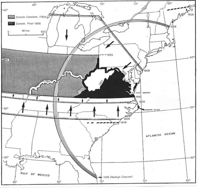
1585-87 Raleigh granted exploitation privileges within a 600-mile radius in the New World; Roanoke Island colony fails, but vicinity receives name of Virginia
1606 London and Plymouth companies granted rights to lands in North America; Virginia re-defined as lying between parallels 34deg.N. and 45deg.N.
1609 London Company rechartered and given exclusive rights to lands in Virginia within 200 miles north and south of Old Point comfort at the tip of Delmarva Peninsula"west and northwest" from sea to sea
1612 London Company rechartered to include islands offshore in Virginia territory between 30deg.N and 41deg.N.
1620 Northern limit of Virginia fixed at 41deg.N.
1629 Heath granted exploitation rights south of 36deg.N., moving southern limit of Virginia north by two degrees
1632 Baltimore granted exploitation rights north of the Potomac River, moving Virginia boundary south by 120 miles
1663 Albemarle group granted exploitation rights to Carolina, defined as south of 36deg.N; northern limits of Virginia in Delmarva Peninsula set at ca. 38deg.N.
1665 Albemarle group re-chartered with southern boundary of Virginia defined at 36deg.30min.N.
1763 Conclusion of Seven Years' War sets western limits of Virginia at Mississippi River
1774 Quebec Act transfers all Virginia claims north of Ohio River to Quebec
1776 Revolutionary government of Virginia reclaims losses of Quebec Act, less overlaping claims by Maryland, Pennsylvania, and Connecticut
1784 Virginia cedes all claims of land northwest of the Ohio River to the US Federal Government.
1789 Virginia permits cession of counties comprising Kentucky territory.
1862 Block of counter-secessionist counties form independent state of West Virginia.
1866 Federal Government detaches two tactically-located Virginia counties and appends them to West Virginia.
Go to Virginia map, 1634-1640
Return to Virginia Maps Introduction page
[adapted from Michael Doran, Atlas of County Boundary Changes in Virginia, 1634-1895], available under General References
|| Virginia/W.Va. || General Reference || Military Records ||
|| Other States || Genealogy Links || New Titles || Home Page || E-Books ||
Copyright 2026 Iberian Publishing Company
|