


Home
Reference
Census Records
Military
African-American
Other States
New Titles
E-BOOKS
FREE SHIPPING IN USA
Iberian Publishing Company's On-Line Catalog:
The Growth of Virginia, 1634-1895
1634-1640
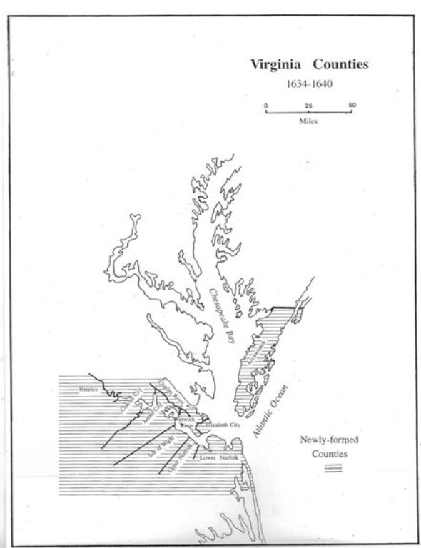 Following a decade of struggle in the Virginia wilderness a political system began to emerge. In 1617 Governor Samuel Argyll identified four "incorporations and parishes" (James City, Charles City, Henrico and Kikotan [Elizabeth City]). By 1624 monthly courts were formed for Charles City and Elizabeth City, and a decade later, in 1634 the original four incorporations became eight new counties. Virginia imitated the contemporary shire structure of the British Isles. The old original corporations of Charles City, Elizabeth City, James City, and Henrico were split to permit creation of Warwick River (Warwick), Warrosquyoake (Isle of Wight)
and Charles River (York), making a total of seven "shires" in the vicinity of the James Estuary. Accawmack was added as an eighth shire encompassing the population of the Eastern Shore.
Following a decade of struggle in the Virginia wilderness a political system began to emerge. In 1617 Governor Samuel Argyll identified four "incorporations and parishes" (James City, Charles City, Henrico and Kikotan [Elizabeth City]). By 1624 monthly courts were formed for Charles City and Elizabeth City, and a decade later, in 1634 the original four incorporations became eight new counties. Virginia imitated the contemporary shire structure of the British Isles. The old original corporations of Charles City, Elizabeth City, James City, and Henrico were split to permit creation of Warwick River (Warwick), Warrosquyoake (Isle of Wight)
and Charles River (York), making a total of seven "shires" in the vicinity of the James Estuary. Accawmack was added as an eighth shire encompassing the population of the Eastern Shore.
1634 - Accawmack (original shire) became Northampton in 1642/43
1634 - Charles City (original shire)
1634 - Charles River (original shire) became York in 1642/43
1634 - Elizabeth City (original shire)
1634 - Henrico (original shire)
1634 - James City (original shire)
1634 - Warrosquyoake (original shire) became Isle of Wight in 1637
1634 - Warwick River (original shire) became Warwick in 1642/43
1636 - New Norfolk (from Elizabeth City) divided and extinguished in 1637
1637 - Isle of Wight (name changed from Warrosquyoake)
1637 - Lower Norfolk (New Norfolk) New Norfolk divided and extinguished
1637 - Upper Norfolk (New Norfolk) Upper Norfolk became Nansemond in 1642/43
Go to Virginia map, 1641-1650
Return to Virginia Maps Introduction page
[adapted from Michael Doran, Atlas of County Boundary Changes in Virginia, 1634-1895], all twenty-four maps available in 11x17 book form atDoran's Atlas
|| Virginia/W.Va. || General Reference || Military Records ||
|| Other States || E-Books || New Titles || Home Page || E-Books ||
Copyright 2026 Iberian Publishing Company
|