


Home
Reference
Census Records
Military
African-American
Other States
New Titles
E-BOOKS
FREE SHIPPING IN USA
Iberian Publishing Company's On-Line Catalog:
The Growth of Virginia, 1634-1895:
1771-1780
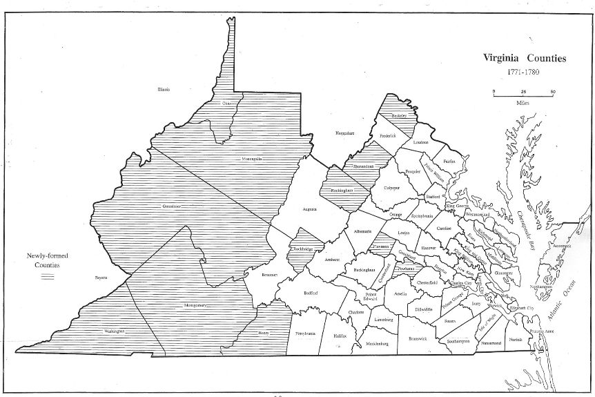
Parliament's decision to reopen portions of the frontier produced further county formations. In 1772 Berkeley and Dunmore were formed from Frederick and Botetourt gave up an immense tract of land which was briefly known as Fincastle. In the years immediately before war broke out in 1775, county formation ceased. It resumed again in 1776 when the district of West Augusta became Monongalia, Ohio, and Yohogania. In 1777 Fincastle was extinguished
and its territory made into Washington, Montgomery, and Kentucky. Later that same year, Albemarle was divided to yield Fluvanna, and Cumberland gave up land to create Powhatan. During 1778. Greenbrier, Rockbridge, and Rockingham were created from the lands of Montgomery, Botetourt, and Augusta; Dunmore was renamed Shenandoah; and all of Augusta's lands beyond the Ohio River became Illinois. In 1780 out of Kentucky County came Fayette, Jefferson, and Lincoln. Kentucy would become an independent state in 1792.
1772 - Berkeley (Frederick)
1772 - Dunmore (Frederick) Became Shenandoah in 1778
1772 - Fincastle (Botetourt)
1776 - Monongalia (Augusta)
1776 - Ohio (Augusta)
1776 - Yohogania (Augusta) Ceded to Pennsylvania in 1786)
1777 - Henry (Pittsylvania)
1777 - Kentucky (Fincastle) Fincastle extinguished
1777 - Montgomery (Fincastle)
1777 - Washington (Fincastle)
1777 - Fluvanna (Albemarle)
1777 - Powhatan (Cumberland)
1778 - Greenbrier (Montgomery, Botetourt)
1778 - Rockingham (Augusta)
1778 - Rockbridge (Augusta, Botetourt)
1778 - Shenandoah (name changed from Dunmore)
1778 - Illinois (Augusta) Ceded to the United States in 1784
1780 - Fayette (Kentucky) Kentucky extinguished
1780 - Jefferson (Kentucky)
1780 - Lincoln (Kentucky)
Go to Virginia map, 1781-1790
Return to Virginia Maps home page
[adapted from Michael Doran, Atlas of County Boundary Changes in Virginia, 1634-1895], available under General References
|| Virginia/W.Va. || General Reference || Military Records ||
|| Other States || Genealogy Links || New Titles || Home Page || E-Books ||
Copyright 2026 Iberian Publishing Company
|