


Home
Reference
Census Records
Military
African-American
Other States
New Titles
E-BOOKS
FREE SHIPPING IN USA
Iberian Publishing Company's On-Line Catalog:
The Growth of Virginia, 1634-1895:
1781-1790
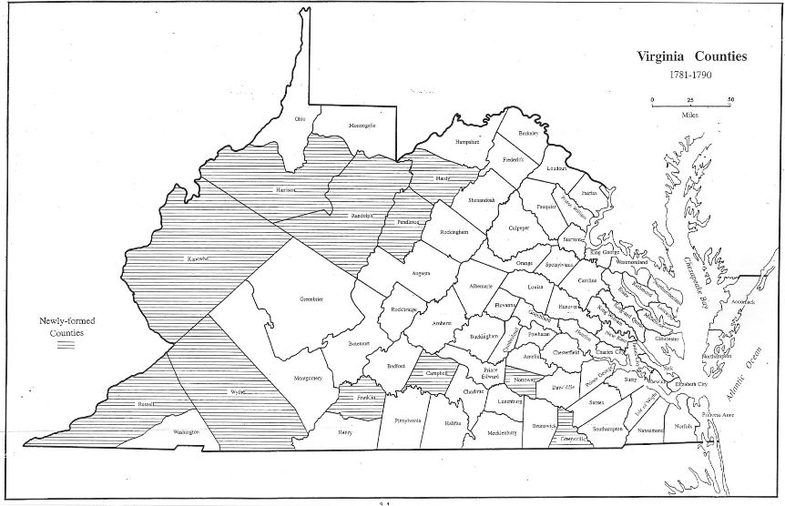
During the 1780s seventeen new counties were added to the growing Virginia scene. Six of these were in the far west, where agitation for an entirely new state had been growing. Even before the Revolution, Williamsburg politicians had recognized that effective control of the distant lands beyond the Alleghenies was not feasible.
In 1783 the General Assembly, now seated in Richmond, ceded all claims to lands north of the Ohio River in favor of Congress, which happily began to sell them off to finance the cost of government and to repay debts assumed during the Revolution. Virginia had also decided to abandon attempts to control the Bluegrass counties, and in 1789, Kentucky began its move toward statehood in 1792
1781 Greensville - (Brunswick)
1782 - Campbell (Bedford)
1784 - Harrison (Monongalia)
1785 - Nelson (Jefferson)
1786 - Franklin (Bedford, Henry)
1786 - Hardy (Hampshire)
1786 - Madison (Lincoln)
1786 - Mercer (Lincoln)
1786 - Bourbon (Fayette)
1786 - Russell (Washington)
1787 - Randolph (Harrison)
1788 - Pendleton (Augusta, Hardy, Rockingham)
1789 - Mason (Bourbon)
1789 - Woodford (Fayette)
1789 - Kanawha (Greenbrier, Montgomery)
1789 - Nottoway (Amelia)
1790 - Wythe (Montgomery
Go to Virginia map: Kentucky, 1771-1780
Return to Virginia Maps home page
[adapted from Michael Doran, Atlas of County Boundary Changes in Virginia, 1634-1895], available under General References
|| Virginia/W.Va. || General Reference || Military Records ||
|| Other States || Genealogy Links || New Titles || Home Page || E-Books ||
Copyright 2026 Iberian Publishing Company
|